Cave Survey Archive
Any serious research which deals with caves requires the use of a survey, or map, of the caves. The Society has, therefore, carried out a great deal of survey work and has published in its Proceedings a large number of cave surveys.
However, the use of computers has made it possible to use survey data in new and different ways. We are therefore making available data from our archives in formats that might be used in novel ways to view aspects of cave layout and structure. In the first instance, we are making available “Survex” 3D files of certain caving areas. Survex is probably the most commonly used cave survey software in the UK and its viewer is one of the most flexible and easy to use. You can download Survex for free. Alternatively, the files can be viewed using the "Therion" viewer. Therion can also be downloaded, from here, for free. As well as Survex, itself, the output has benefitted from the use of Mike McCombe's TerrainTool to add surface detail. TerrainTool is hosted by the Society on Mike's behalf.
Although the output files are being made freely available, for the underlying data this is not always the case. This is partially because much of the data has been contributed by others and we do not hold copyright on it, plus we have not found a non-labour intensive way to do it. We will continue to endeavour to release as much data as possible, both on this page as a static snapshot, but also the 'live' versioned repository on the BCA Cave Data Archive, maintained by the Cave Surveying Group.
Contents
Burrington Area Survey
Project Details
This project arose from the need to supply comprehensive survey data for a study of the cave geomorphology of all the caves of the Burrington Combe area. The Area Survey is a compilation of data on all the caves. It is held as a Therion file and the output consists of a 3D file (lox format) readable by Therion. A Survex 3D version, readable by Aven is also available.
File downloads
All of these files are released under a
Creative Commons license.

The Burrington Area Survey "Survex" 3D file compiled by University of Bristol Spelaeological Society
The Burrington Area Survey "Therion" 3D file
by University of Bristol Spelaeological Society
Contains Ordnance Survey data © Crown copyright and database right 2010
The 1997 survey of Bos Swallet in pdf format.
The 2008 survey of Drunkard's Hole in pdf format.
The 2013 survey of Pierre's Pot in pdf format.
The 2015 survey of Read's Cavern in pdf format.
The 2016 survey of Tween Twins Hole in pdf format.
Contributors
The original data comes from the sources listed below. Plans based on this data have been published in some cases and the references are given also. This is not a comprehensive list of previous published surveys , but only those based on parts of this dataset.
- Aveline's Hole: Data from Dr Roger Stenner, original publication by BEC (Howell, C., Irwin, D.J. and Stuckey, D. A Burrington Cave Atlas BEC Caving Report 17.)
- Bos Swallet: Data from UBSS
- Drunkard's Hole: Data from Carmen Smith
- East Twin Swallet, Spar Pot, Lionel's Hole: Data from David Cundy
- Goatchurch Cavern: Data from Chris Binding/UBSS
- Goon's Hole: Data by courtesy of Martin Mills and Bob Mehew. Survey originally published in SMCC Journal series 5 No. 1 pp10-12, 1971.
- Pierre's Pot: Data from P. & A. Moody, Steve Cottle, J. Cordingley & Kev Hilton & Clare Cohen. Earliest publication by UBSS (Mullan,G.J., 1999. Mendip Cave Notes. UBSS Proceedings, 21. (2) pp 189-191)
- Read's Cavern: This dataset from Andrew Atkinson and collaborators, 2013-15.
- Sidcot Swallet: Data from Carmen Smith & Andrew Atkinson
- Tween Twins: Data from Andrew Atkinson, Jonathan Williams and Tim Clements
- Rods Pot and Bath Swallet: Data from Andy Sparrow and the Cheddar Caving Club.
It is intended, in so far as it is possible, to keep this dataset up to date. Any queries about this project and any offers of additional data should be sent to editor[at]ubss.org.uk
Cheddar Catchment Area Survey
This project also arose from the need to support a geomorphological study, this time owing to the major finds that have been made in Charterhouse Cave since 2008. Again, this has been a collaborative project drawing on the work of many Mendip surveyors and clubs. It is also intended to add to this dataset as more information becomes available and to make it as comprehensive as possible. The current version includes cave finds and surveys to the end of 2011. Archive data is being added as it becomes available and is transcribed.
File downloads
All of these files are released under a
Creative Commons license.
The Cheddar Catchment Area Survey "Survex" 3D file compiled by University of Bristol Spelaeological Society
A more complex and therefore larger file is also available for viewing using only the "Therion" viewer. This model remains very much "work in progress" and is being updated and improved as our dataset is added to and improved.
The Cheddar Catchment Area Survey "Therion" 3D file
compiled by University of Bristol Spelaeological Society
Contains Ordnance Survey data © Crown copyright and database right 2010
The latest plan version of Charterhouse, Tyning's Great Swallet and G.B. in pdf format.
The Gough's Cave Survey (to 2013) plan and elevation of the dry cave and downstream sumps in pdf format.
The Gough's Cave Survey (to 2015) plan and elevation of the whole cave in pdf format.
The latest (December 2013) version of the Reservoir Hole and White Spot Cave survey in pdf format.
The 2004 survey of Tyning's Great Swallet in pdf format.
The 2011 survey of Palmer's Cave in pdf format.
The 2011 survey of White Spot Cave in pdf format.
The 2012 survey of The Whitebeam Slitter Caves in pdf format.
The 2013 survey of Cooper's Hole in pdf format.
The 2013 survey of Gough's Old Cave in pdf format.
The 2013 survey of Great Oone's Hole in pdf format.
The 2013 survey of Long Hole in pdf format.
The 2013 survey of Bowery Corner Swallet in pdf format.
The 2014 survey of Spider Hole in pdf format.
The 2016 survey of Pig's Hole in pdf format.
The 2017 survey of Sun Hole in pdf format.
The BCA Data Repository is trackable at http://www.cave-registry.org.uk/svn/CheddarCatchment/ We are grateful to all those listed below for freely sharing their data in this way.
Some statistical queries of the original data can be made on this page. It would be useful to receive feedback as to how useful users find these queries and what similar questions you might also find useful.
Contributors
The original data comes from the sources listed below. Plans based on this data have been published in some cases and the references are given with links where available. This is not a comprehensive list of previous published surveys, but only those based on parts of this dataset.
- Attborough Swallet: Data by kind courtesy of Trevor Hughes.
- Blackmoor Swallet, or Stainsby's Shaft: Data by kind courtesy of Alan Gray.
- Bone Hole: Data by kind courtesy of MCG and Andrew Atkinson.
- Bowery Corner Swallet: Data by kind courtesy of Andrew Atkinson and Henry Dawson.
- Charterhouse Cave: Data from P. & A. Moody and the Charterhouse digging team Pete Moody, Alison Moody, Pete Hann, John Cooper, Andrew Atkinson and Simon Flower. Plan originally published in 1984.
- Cooper's Hole: This survey by Andrew Atkinson and Clive Owen.
- G.B. Cave: Data from UBSS, plans originally published by UBSS in 1951, 1969 and 1984. Ladder Dig extensions have been resurveyed and redrawn by Andrew Atkinson.
- Gough's Cave: Surveyed by UBSS/CDG 2010/11.
- Gough's Old Cave, Long Hole and Great Oones Hole: originally surveyed by W.I. Stanton. Available from Mendip Cave Registry and Archive. The above surveys are new and were completed 2013-15 by a team led by Andrew Atkinson.
- Grebe Swallet: Data from W.I. Stanton, plans originally published by UBSS in 1991.
- Longwood Swallet: Originally surveyed by MCG, drawn by Mike Rennie in 1961 and revised by Tony Knibbs in 1984. Available from Mendip Cave Registry and Archive. Digitised by Phil Rowsell; Reynolds Passage digitised by Alex Crowe.
- Manor Farm Swallet: Originally surveyed by W.I. Stanton and published in 1974. Additional data supplied by P.L. Smart & T.C. Atkinson and a revised plan was published in 1999. Data on the 2010 extensions and including the Rifts and Ruckles kindly supplied by Phil Rowsell. This dataset does not include Sarum Inlet, discovered and surveyed by the Salisbury Caving Group.
- Palmer's Cave (Tynings Field Dig): Surveyed by Andrew Atkinson and Alison Moody 2011.
- Reservoir Hole: By courtesy of the Tuesday Diggers & UBSS.
- Rhino Rift: Originally surveyed by W.I. Stanton and published by WCC. This is original data kindly provided by Phil Rowsell.
- Spider Hole: Surveyed by Andrew Atkinson, Pete Hann and Adrian Vanderplank 2011.
- Totty Pot: Surveyed by UBSS 2005.
- Tynings Barrows Swallet: Originally surveyed by BEC and GSG, drawn by D.J. Irwin and published by BEC. Available from Mendip Cave Registry and Archive. Digitised by Alex Crowe and Andrew Atkinson.
- Tynings Great Swallet: Data from Tony Boycott. Survey originally published in 2005.
- Upper Flood Swallet: All data by kind courtesy of the MCG. The original survey is available from their website.
- Waterwheel Swallet: Data from W.I. Stanton, plans originally published by UBSS in 1987.
- Whitebeam Slitter Cave and nearby caves: This survey by Andrew Atkinson, Tony Boycott, Alison Moody and Clive Owen.
- White Spot Cave: Surveyed by Andrew Atkinson and Graham Mullan 2011.
- Wigmore Swallet: Data by kind courtesy of Trevor Hughes and Chris Jewell.
- The surface survey has been generated by Mike McCombe's TerrainTool; additional information from Bill Chadwick.
Thanks are due to all the above. Most of the technical stuff has been done by Andrew Atkinson; Graham Mullan typed in much of the archive date.
The Caves of County Clare, Ireland
Much of the fieldwork carried out by the Society over the years has been in Co. Clare Ireland and we have been responsible for surveying over 50 km of passage, there. Descriptions of the caves, including many surveys are available in both our Proceedings and in our guide book to the area, The Caves of County Clare and South Galway. Most of the data has been supplied by members of the Society, but some is from other sources. Particular thanks must go to Colin Bunce, Quentin Cowper and other members of the Spelaeological Union of Ireland and, especially, the Burren Crawlers. It is hoped to improve this dataset and keep it up to date, as well. As above, any queries about this project and any offers of additional data should be sent to editor[at]ubss.org.uk
The "Survex" 3d version of this model does not have a surface overlay included as this makes for a very large file which is difficult to view. The "Therion" version does have a surface overlay which shows the relief. It does not, as yet, have a pictorial overlay, either photographic or mapping, as we do not, as yet, have one that is available to us. This will be added as soon as an open source version is available.
File downloads
All of these files are released under a
Creative Commons license.
The Caves of the Burren "Survex" 3D file compiled by University of Bristol Spelaeological Society
The 2016 survey of Cullaun Zero-One in pdf format.
The 2016 survey of Cullaun Zero in pdf format.
The 2018 survey of Cullaun One and associated caves in pdf format.
The 2018 survey of The Coolagh River Cave in pdf format.
The Caves of the Burren "Therion" 3D file compiled by University of Bristol Spelaeological Society
The BCA Data Repository is trackable at http://www.cave-registry.org.uk/svn/CountyClare/
The Caves of County Mayo, Ireland
The title of this section is slightly misleading, as the drainage system discussed here actually straddles the border between Counties Mayo and Galway. The name has been chosen to avoid confusion with the major drainage systems in the Kinvarra/Gort area further south in Co. Galway.
The survey work listed here has been carried out by members of the Society in a series of annual visits, commencing in 2012. Details of these visits can be found on this page. Only the surveys are given here. Most of the plan surveys have been published in the reports in our Proceedings. The 3D models, obviously, are only available here.
We are also grateful to Martyn Farr for generously sharing data from his dives in the area with us.
File downloads
All of these files are released under a
Creative Commons license.
The Caves of the West Cong Area "Survex" 3D file compiled by University of Bristol Spelaeological Society
The Caves of the West Cong Area "Therion" 3D file compiled by University of Bristol Spelaeological Society
The 2012 survey of Ballymaglancy Cave in pdf format.
The 2014 survey of Ballymaglancy Resurgence Cave in pdf format.
The 2014 survey of Cat's Hole in pdf format.
The 2015 compilation survey of Pigeon Hole in pdf format.
The 2015 compilation survey of Wolves' Hole in pdf format.
A 2015 compilation survey of Pigeon Hole and Wolves' Hole in pdf format.
A 2015 compilation survey showing caves from Ballymaglancy to Cat's Hole in pdf format.
The BCA Data Repository is trackable at http://www.cave-registry.org.uk/svn/CountyMayo/
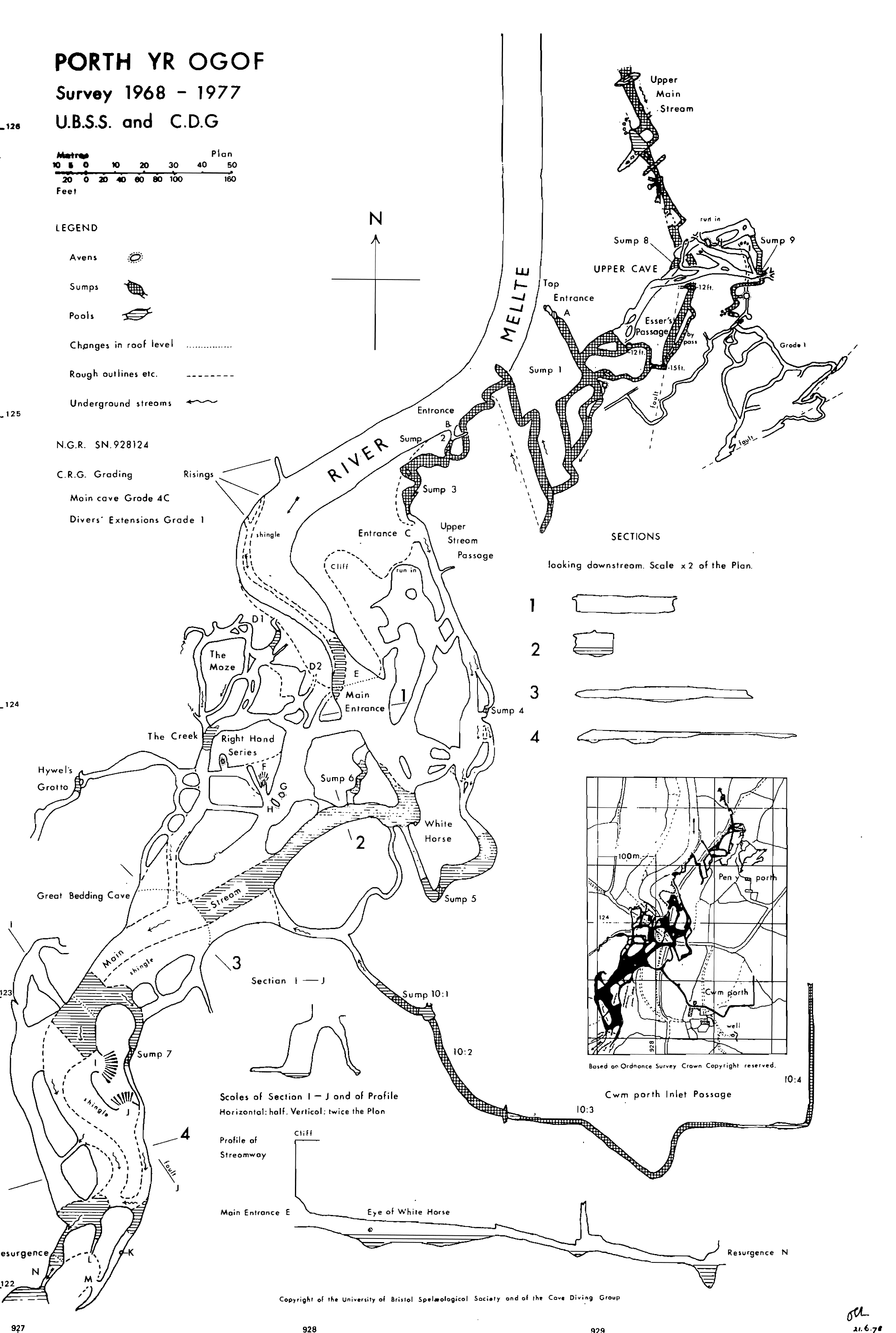
The Little Neath River Cave
This South Wales cave was discovered by the Society in the 1960s and explored and surveyed between 1967 and 1987. Three reports on the cave were published in our Proceedings, a preliminary report, by Mike Norton, Dave Savage and Peter Standing; the most comprehensive report by Standing, Malcolm Newsom and Adrian Wilkins and a follow up by Graham Mullan. "Neath" was the first cave survey to be compiled by the Society using computer software rather than traditional methods. The current 3D file, however, is a modern production. The survey work was carried out by a large number of Society members, with assistance from members of other clubs, in particular the Cave Diving Group, the Cwmbran Caving Club and the Westminster Speleological Group. We are grateful for their support. The Survex version of the file also has surface detail added, using data generated with Mike McCombe's "TerrainTool" utility. Just turn on "view surface legs". The Therion version has the same topographic detail, but overlain by Ordnance Survey mapping detail.
File downloads
All of these files are released under a
Creative Commons license.
The 1988 plan drawing of the cave as a pdf
The Little Neath River Cave "Survex" 3D file by University of Bristol Spelaeological Society
The Little Neath River Cave "Therion" 3D file
by University of Bristol Spelaeological Society
Contains Ordnance Survey data © Crown copyright and database right 2010
The BCA Data Repository is trackable at http://www.cave-registry.org.uk/svn/Neath/
The River Lathkill Catchment Area
This project arose out of the need to inform a project relating to the relative water levels and flow within the upper reaches of the River Lathkill, in Derbyshire. The data has virtually all been supplied by cave surveyors active in the Peak District. We are particularly grateful to Ron Hammond, Mel Milner and Wayne Sheldon for their efforts in collecting and collating survey data, though the efforts of many other individual workers are also recorded within these models. There are two versions of the model: the Survex version shows cave centrelines and other entrances/sites but has no surface detail. The Therion version has added topographic data, from "TerrainTool" overlain with Ordnance Survey mapping detail.
File downloads
These files are released under a
Creative Commons license.
The River Lathkill Catchment "Survex" 3D file by University of Bristol Spelaeological Society
The River Lathkill Catchment "Therion" 3D file
by University of Bristol Spelaeological Society
Contains Ordnance Survey data © Crown copyright and database right 2014
The BCA Data Repository is trackable at http://www.cave-registry.org.uk/svn/Lathkill/